This is an old revision of the document!
SpatiaLite Interpretation Database
Introduction
Geocene3D uses a SpatiaLite database to store interpretation points. SpatiaLite is an extension of SQLite that adds support for spatial data, enabling the storage and management of point geometries directly within the database. The database is generated during Setting Up Data for Modeling.
Each interpretation point layer in Geocene3D is stored as a separate table in the database. These tables include a geometry field named xypoint, which holds the spatial location of each interpretation point as a two-dimensional coordinate.
The xypoint field is of type POINT and uses SpatiaLite’s spatial format to store each point’s position in terms of Easting (X) and Northing (Y) coordinates.
Table Structure
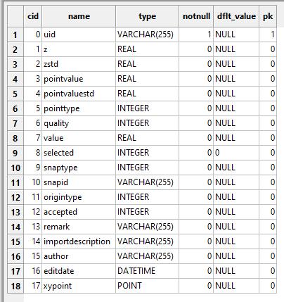
Each interpretation point table in the database includes the following fields:
uid: VARCHAR(255) — unique identifier (primary key)
z: REAL — elevation value
zstd: REAL — standard deviation of elevation
pointvalue: REAL — value associated with the point
pointvaluestd: REAL — standard deviation of the point value
pointtype: INTEGER — numeric code for point type
quality: INTEGER — quality score
value: REAL — optional additional value
selected: INTEGER — flag indicating if the point is selected
snaptype: INTEGER — snapping type information
snapid: VARCHAR(255) — identifier for snapped feature
origintype: INTEGER — origin type code
accepted: INTEGER — accepted status
remark: VARCHAR(255) — textual note or comment
importdescription: VARCHAR(255) — description related to import
author: VARCHAR(255) — name of the person who created or imported the point
editdate: DATETIME — timestamp of the last modification
xypoint: POINT — geometry field storing the coordinates as Easting and Northing
Geometry Field: xypoint
The xypoint field stores the location of each interpretation point as a pair of coordinates:
Easting — the horizontal position (X)
Northing — the vertical position (Y)
These coordinates are stored in the geometry field using a specific EPSG code, which defines the coordinate reference system used when the data is visualized externally.
Important: Geocene3D itself does not use projections internally. The EPSG code only matters when the database is opened in external software such as QGIS, where the coordinates need to be placed correctly on a projected map. The EPSG value is defined by the user during the modeling setup process (Setting Up Data for Modeling) to ensure consistency when exchanging data with mapping tools.
Required Field: GUID in Specific Format
The database require a GUID (Globally Unique Identifier) to uniquely identify each entry. A GUID is a 128-bit value written as a string in a fixed format, using five groups of hexadecimal digits separated by hyphens, in the 8-4-4-4-12 pattern.
This is the exact format used in Geocene3D:
{D362ABBF-E812-4276-B216-AE55CB04B187}
Format rules:
The value must begin and end with curly braces {}
All letters must be uppercase
Hyphens must follow the 8-4-4-4-12 grouping
The total length must be 38 characters, including the braces
Important: The GUID must be generated using code that produces valid and unique identifiers.
Copying GUIDs is not allowed — not even between different tables or layers. Every point must have its own unique GUID, even if it belongs to a separate interpretation layer. Manually typed, duplicated, or reused values will not be accepted and may break uniqueness or cause conflicts in further processing.
Using the Database in QGIS
You can view and work with the Geocene3D SpatiaLite database in QGIS:
- Open QGIS
- Go to
Layer > Add Layer > Add SpatiaLite Layer - Click “New” to connect to your
.sqlitedatabase file - Select the database file and click “Open”
- QGIS will now list all spatial tables that contain geometry
- Select the table containing the interpretation points and click “Add” to load it into the map
When loaded, QGIS will use the EPSG code stored in the geometry metadata to display each point at the correct Easting and Northing coordinates on the map.


