
Exporting Data from GeoScene3D to GeoCloud
GeoScene3D includes a built-in feature for exporting surveys of 1D geophysical data directly to GeoCloud.
GeoCloud requires certain data types to be uploaded in specific formats.
In addition to the data files themselves, an accompanying .ini file (GeoCloud - INI Files) can be of useful help to define how the data should be interpreted during upload. GeoScene3D can be used as a convenient converter to prepare these files automatically.
Supported Data Types
The Export GeoCloud File feature can be used for several 1D Geophysical surveys (Electromagnetic Data [formats: .xyz, .csv, .mdb/accdb]). The export creates two segments:
- The 1D data files ( .csv)
- An accompanying .ini file containing metadata and import settings

How to export from GeoScene3D
- In the Object list, right-click the dataset you want to export.
- Select Properties.
- Open the Data tab.
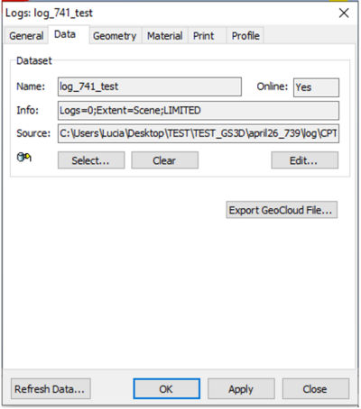
- Click Export GeoCloud File… .
- Choose an output folder and complete the export.

GeoScene3D will generate all files required for the upload to GeoCloud.
NB:These files often contain usefull information in the header of the file, like if the layers are measured by elevation or depth. Thus it is a good idea to open the files and look for yourself what information is given, because this helps you to ensure that the upload to GeoCloud works correct and smoothly.
You can find a guide on how to upload files in GeoCloud here.